


boivin

pascal.gateau
User
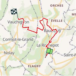

Length
12.2 km

Max alt
556 m

Uphill gradient
287 m
Km-Effort
16.3 km

Min alt
386 m

Downhill gradient
383 m
Boucle
No
Creation date :
2019-06-01 04:58:13.118
Updated on :
2019-06-01 11:15:35.667
4h00
Difficulty : Very easy

FREE GPS app for hiking
 SityTrail
IGN / Geographical institutes
SityTrail Plus
The world is yours!
About
Trail Walking of 12.2 km to be discovered at Bourgogne-Franche-Comté, Côte-d'Or, La Rochepot. This trail is proposed by pascal.gateau.
Positioning
Country:
France
Region :
Bourgogne-Franche-Comté
Department/Province :
Côte-d'Or
Municipality :
La Rochepot
Location:
Unknown
Start:(Dec)
Start:(UTM)
627516 ; 5200742 (31T) N.
Comments